“中国内蒙古的肥沃草原曾一度因为过度的放牧、伐木、扩大农场、人口压力、风力和干旱而饱受荒漠化的侵扰。在过去的20年间,依靠地方和国家的帮助,约有300万英亩的荒地得到了恢复。为了纪念几代人为荒漠化防治所付出的努力,一座具有教育意义的公园和观景平台被建造在广阔的文冠庄园顶端。设计师利用当地的材料、植物和方法搭建了一系列简洁而美观的结构,以框架的形式凸显出重获新生的自然景观,并借助增强现实向人们讲述了这一值得铭记的变革故事。”
– 2019年评审委员会“The once-fertile grasslands of Inner Mongolia in China have suffered from desertification caused by overgrazing, logging, expanding farms, population pressure, wind, and drought. In the past 20 years, approximately three million acres of desert have been rehabilitated through local and national efforts, which are celebrated in this educational park and observation platform in the middle of a yellowhorn farm. The designers bridge the past and the future by using local materials, plants, and construction methods to create simple, beautiful structures and viewing platforms that frame the reborn landscapes, and which use augmented reality to tell the remarkable story of transformation.”
– 2019 Awards Jury
来自 ASLA 对gooood的分享。
Yellowhorn Farm Park | China Construction Design Group
项目概述
PROJECT STATEMENT
敖包山顶公园项目建造于2014年,位于内蒙古敖汉旗的一片150英亩的文冠果农田顶端。内蒙古是中国的第三大省区,与荒漠化的艰苦斗争可以追溯至一个多世纪以前。过度放牧、伐木、扩建农场、人口压力、大风和干旱将曾经肥沃的草原变成了沙地。在过去的20年间,依靠地方和国家的帮助,约有300万英亩的荒地得到了恢复。从荒蛮的沙漠到欣欣向荣的农田,敖包山公园所在的场地是此类转变中最具代表性的例子之一。公园观景台所在的特殊位置原先坐落着一栋临时办公建筑,在防治荒漠化的年月里充当枢纽,为数千名工人提供了监测、组织和休息的场地。为了尽可能地减少对环境的干扰,景观设计团队将历史性的资源(例如材料、植被和建造方法)和当代功能(例如教育、娱乐和技术集成)进行了整合,在纪念几代人为抵御荒漠化所付出的努力的同时,为当地带来生态、休闲、教育和经济等多方面的利益。
The Yellowhorn Farm Park project, built in 2014, is a 150-acre hilltop of yellowhorn farmland located in Aohan County in Inner Mongolia, China. Inner Mongolia is China’s third largest province, and has been battling severe desertification for over a century. Over-grazing, logging, expanding farms, population pressure, wind, and drought have all turned this once-fertile grassland into sandy a plain. In the past 20 years, approximately three million acres of desert have been rehabilitated through enormous local and national effort. This project site is one of the most representative fields of this type of transformation, from severe desert to flourishing farm. The particular location of the overlook platform of this park was an onsite temporary office, during those years of fighting desertification, serving as a hub, providing space for observation, organization, rest, and service to thousands of workers devoted to fighting desertification. With an intention towards minimal environmental intervention, the landscape design team integrated historical resources (i.e., materials, plants, and construction methods) with contemporary uses (i.e., education, recreation, and technology integration) to commemorate several generations of effort to combat desertification and provide ecological, recreational, educational, and economic benefit to the local area.
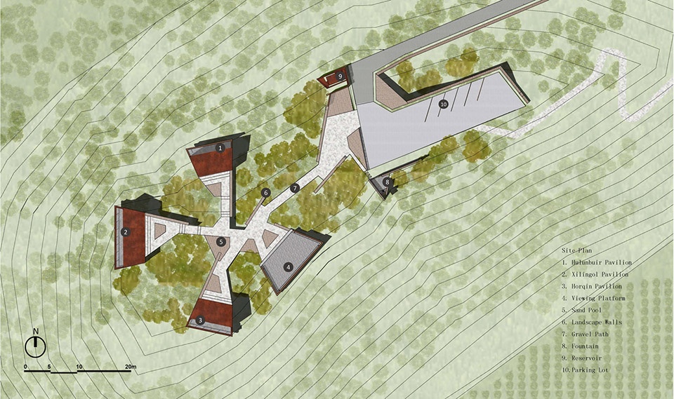
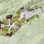
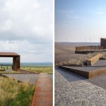
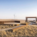
▲场地平面图:公园整体由三个半露天的观景亭、一个全开放的观景平台、景观墙、历史纪念点、休闲设施以及东侧的停车场组成。Site Plan: The whole park consists of three semi-open pavilions, one full-open viewing platform, landscape walls, historical or memorial spots, amenities, and a parking lot on the eastside.
项目说明
PROJECT NARRATIVE
设计背景
文冠果(Yellowhorn)一种能够在极端沙漠气候中生存和繁衍的本地植物,具有稳定土壤和保持水分的功能,还会结出富含油料的果实。在如今的场地中,文冠果田的面积达到150英亩,促进了当地的经济发展和居民迁入。这片农田还被整合到更大范围的风电工程中,为当地村庄提供了可再生能源。该项目由文冠展览中心和敖汉旗政府在2013年共同发起,其目的是纪念蒙古高原多年以来在荒漠化防治方面所付出的努力,证明荒漠向繁荣农场转变的可能性,同时借助景观设计为乡村带来活力。景观团队与当地政府、社区、村民、农场员工以及来自农业、地质、生态和人文领域的科学家开展了一系列公共会议,为该项目赋予了真正意义上的在地性,使其与当地遗产、风土人情以及防治荒漠化的精神紧密相连。
呼应历史的景观设计
景观设计整体呈现出向外发散的同心圆形状,由三个半开放的观景亭和一个完全开放的观景平台组成。公园的几何形状受到文冠果树叶脉络的启发,呼应了这一植物在逆转荒漠化和促进当地经济繁荣方面所发挥的重要作用。三个观景亭被设置在不同的方向,分别代表了蒙古高原上其他三个具有历史意义的荒漠化治理地区:呼伦贝尔草原(朝北)、锡林郭勒草原(朝西)以及科尔沁草原(朝南)。这三处景观共同形成了一个新的历史性场所,象征着逆转蒙古高原荒漠化的自然和历史实践。
有形和无形的互动
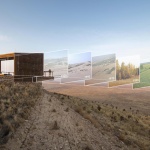
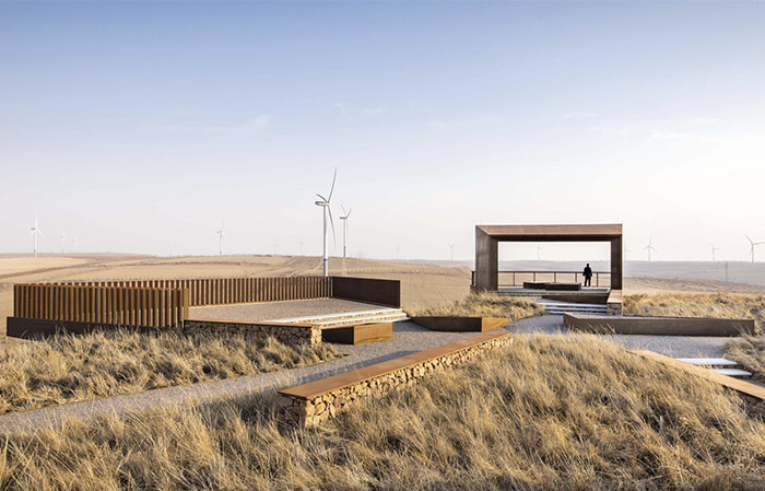
作为观景台的一部分,图形化的框架结构旨在呈现出文冠庄园的优美风貌,同时也作为对场地对抗荒漠化的历史的回应。增强现实技术(AR)被特别地应用到观看体验的营造当中。设计团队与历史学家和当地政府合作创建了一系列按时间顺序排列的数字化场景,讲述了在荒漠化防治过程中具有重要意义的故事。参观者可以一边体验真实的空间,一边借助现场的AR设备与场地进行虚拟互动,从而将治理荒漠化的历史与创见性的未来景观在视觉框架中进行叠加。
生态友好的设计和建造
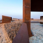
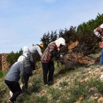
景观设计采用了从当地挖掘的岩石、泥土、废弃的机械部件以及天然的本地植物;这些元素被重新利用到新建的景观结构和道路当中。原先被用来种植文冠果的机械部件和从当地开采的天然石材共同为景观增添了历史性的特征。为了在寒冷、干燥且多风的气候下塑造具有高度适应能力的景观,团队参考了当地耐旱房屋的建造方法,采用砾石、夯土和天然石材来搭建结构,并在其周围和内部种植沙棘、芒草和文冠果等本地植物。为期六个月的建造过程并无专业建筑团队的参与,而是完全依赖于当地的资源和村民。
多样的用途
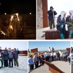
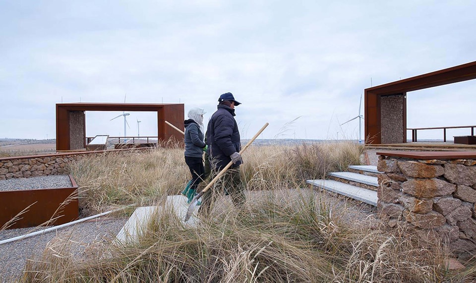
景观结构的基本用途包括纪念、娱乐、教育、摄影、自然观察、休闲以及举办乡村活动等。开放空间、公共舞台、社交空间和娱乐设施的分布展现出流动性、灵活性和文化上的互动性,为当代用途和特定的传统文化活动(如蒙古族歌舞)提供了适宜的场地。同时,一些带有传统标志和图案的展示结构被特意地整合至开放空间,用于进行潜在的展览、纪念和教育活动。作为文冠展览中心的一部分,这处风景优美的场地不仅吸引了大量公众前来参观,还会定期举行各类活动,包括全国文冠贸易峰会和当地学校开展的课程和夏令营等。
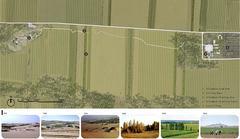
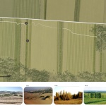
▲场地环境:从荒蛮的沙漠到欣欣向荣的农田,该项目所在的场地是此类转变中最具代表性的例子之一。公园坐落在150英亩的文冠果田内,与展览中心相连接。Site Context: This project site is one of the most representative fields of the transformation, from severe desert to flourishing farm. The park connecting to the exhibition center is embedded within the 150-acre yellowhorn farmland.
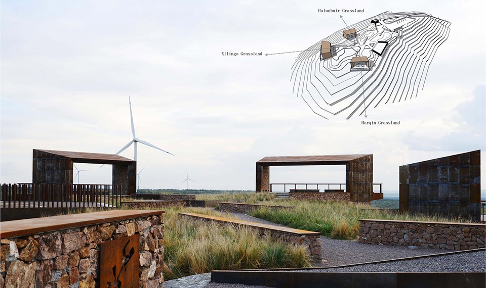
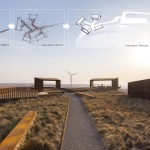
▲观景亭设计理念:三个观景亭被设置在不同的方向,分别代表了蒙古高原上其他三个具有历史意义的荒漠化治理地区:呼伦贝尔草原(朝北)、锡林郭勒草原(朝西)以及科尔沁草原(朝南)。Concept of Viewing Pavilion Design: The three semi-open viewing pavilions positioned in different directions represent the other three historical campaigns waged against desertification on the Mongolian Plateau: Hulunbuir grassland (to the north), Xilingol grassland (to the west), and Horqin grassland (to the south).
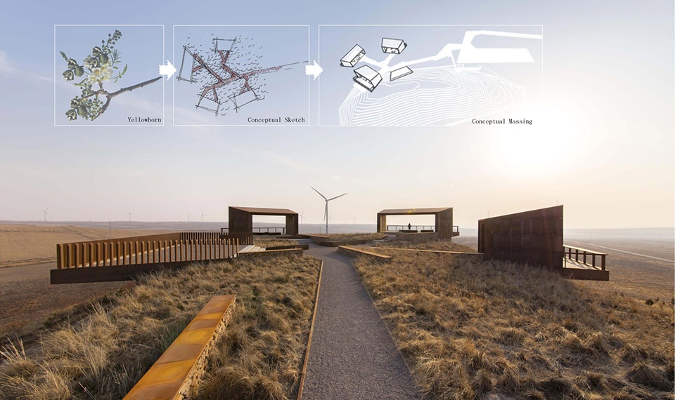
▲设计生成示意:公园的几何形状受到文冠果树叶脉络的启发,呼应了这一植物在逆转荒漠化和促进当地经济繁荣方面所发挥的重要作用。Design Generation: The geometry of the park was inspired by the leaf structure of the yellowhorn tree, a plant species that has been instrumental in reversing the area’s desertification and promoting local economic prosperity.
▲肌理与几何形态:步道、景观墙、观景平台和沙池之间的肌理和几何关系同样反映了文冠果树和树叶的脉络结构。Texture and Geometry: The textures and geometric relations among roads, landscape walls, viewing platforms, and the sand pool are also reflecting the design concept of the Yellowhorn tree and leaf structure.
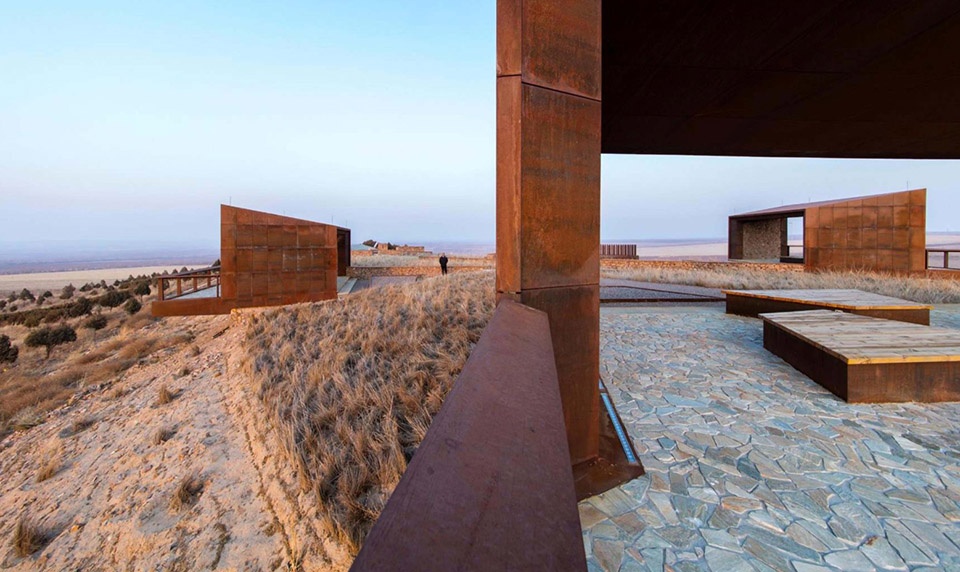
▲形态关系:四个主要的观景结构相互关联,呈现出清晰有序的整体形态。Morphological Relationship: Four main viewing platforms were structured and inter-correlated to form a well-organized morphology.
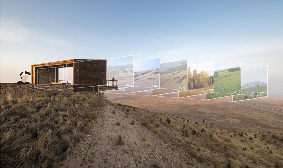
▲有形和无形的互动:增强现实技术(AR)被特别地应用到观看体验的营造当中。一系列按时间顺序排列的数字化场景讲述了在荒漠化防治过程中具有重要意义的故事。Tangible and Intangible Viewing Interaction: Augmented reality technology was particularly introduced to the viewing experience, and a chronological series of digital scenarios representing stories significant to the battle against desertification were added to onsite augmented reality devices.
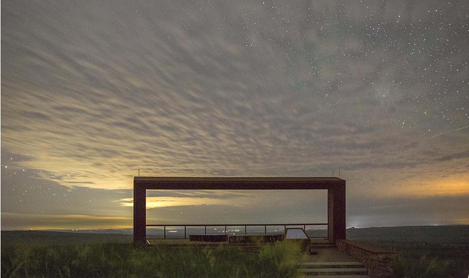
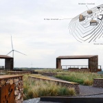
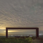
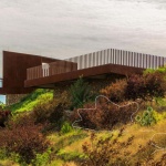
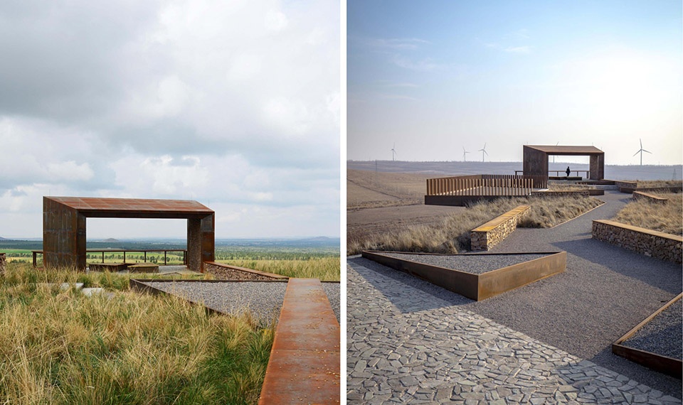
▲朝向锡林郭勒草原的观景亭:框架式的结构能够增强沉浸式的观景体验。Xilingol Grassland Pavilion: The framed structure is to enhance the immersive picture-viewing experience.
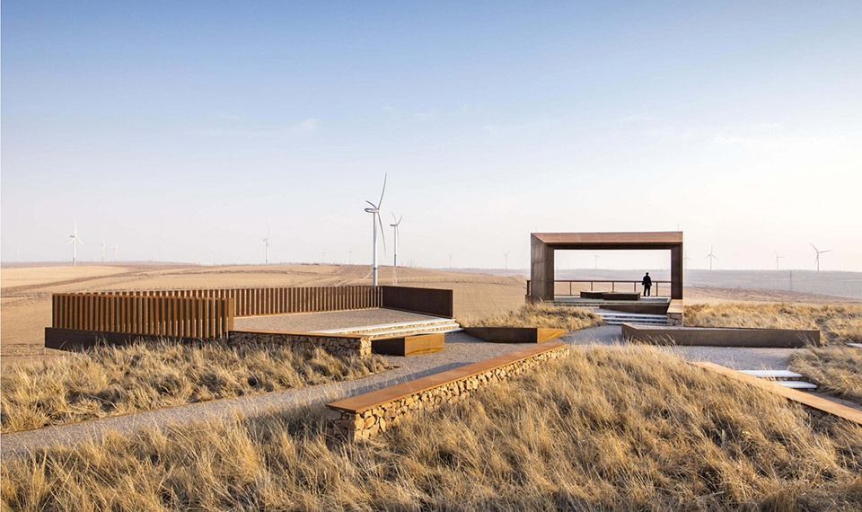
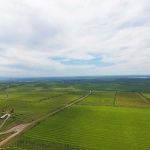
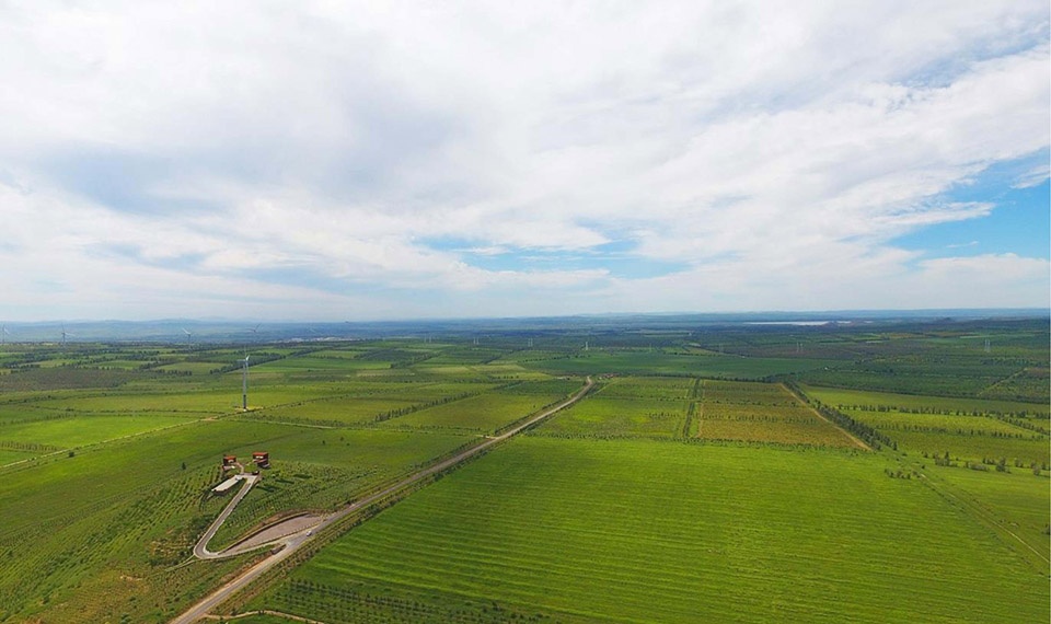
▲农田和可再生能源设施:150英亩的农田被整合到更大范围的风电工程中,为当地村庄提供了可再生能源。Farmlands and Renewable Energy Facilities: This 150-acre yellowhorn farmland has been integrated within a greater wind energy program supplying renewable energy for both farmlands and local villages.
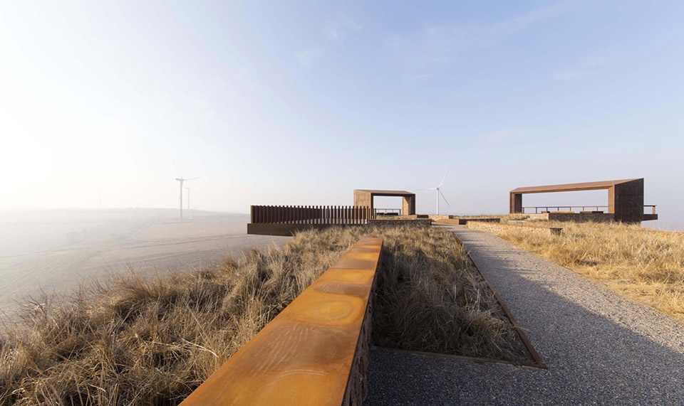
▲观景平台:俯瞰风景的平台被设置在山顶,为游客带来壮观的风景。Overlook Platform: The overlook platforms are placed on the hilltop of the farmland, providing grand view of nature to visitors.
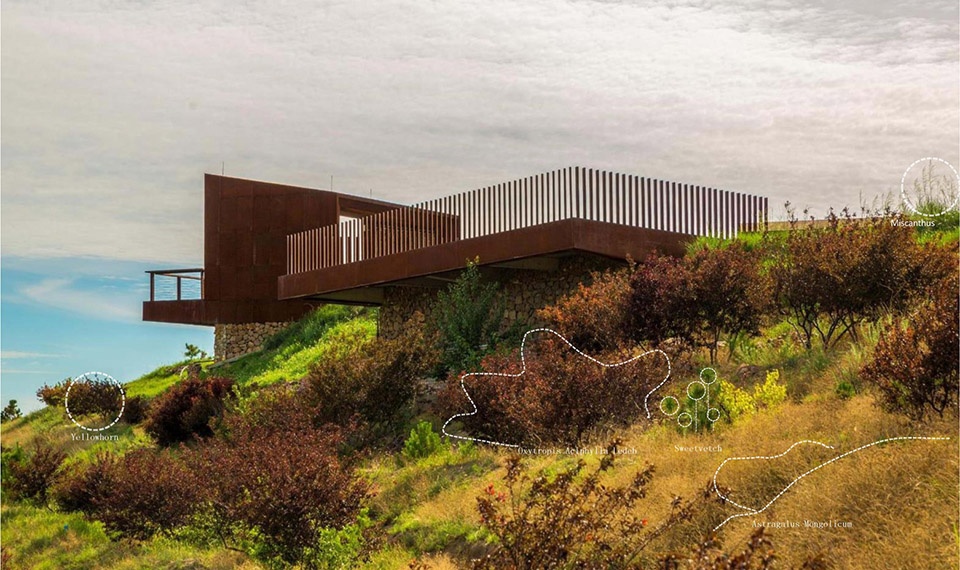
▲景观植被:景观结构周围只选种了耐旱的本地植物,包括沙棘、芒草、岩黄芪和文冠果等。Landscape Plants: Only native drought-tolerant species (sea-buckthorn, miscanthus, sweetvetch, astragalus mongolicum, and yellowhorn) are planted around the landscape architecture.
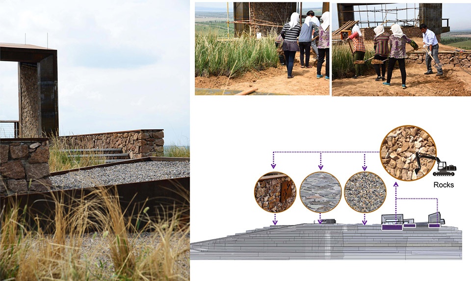
▲石块和土壤的再利用:从当地挖掘的岩石和泥土全部被重新利用到景观设计中。Reuse of Excavated Rocks and Soils: The excavated rocks and soils from the project site during the construction procedure were fully repurposed in the landscape architecture.
▲传统的施工方法:为了在寒冷、干燥且多风的气候下塑造具有高度适应能力的景观,团队采用了传统的施工方法,采用砾石、夯土和天然石材来搭建结构。Traditional Construction Method: To build a resilient landscape in this cold, dry, and windy climate, traditional construction methods including cyclopean masonry with rammed mud and natural stones were adopted.
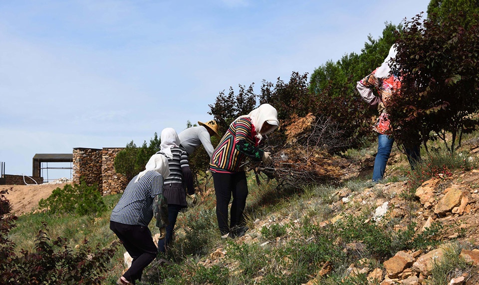
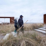
▲参与式的建造过程:为期六个月的建造过程由当地的20位村民合作完成,并未采用专业的建造团队。Participatory Building Procedure: The six-month landscape construction procedure was led by and also involving about twenty local village residents, without professional construction teams.
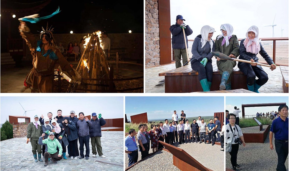
▲多样的用途:景观结构的基本用途包括纪念、娱乐、教育、摄影、自然观察、休闲以及举办乡村活动等。Multi-functional Use: The current functions of the landscape structure include memorial, recreation, education, photography, nature watching, resting, and village events.
▲可期的未来:公园的建造不仅象征着防治荒漠化的历史,还为当地带来生态、休闲、教育和经济等多方面的利益。Visionary Future: Yellowhorn farming is not only representing the history of fighting desertification but also providing ecological, recreational, educational, and economic benefit.
PROJECT NARRATIVE
Design Context
Yellowhorn is a native species that thrives in harsh desert climates, stabilizes soil, retains moisture, and provides oil-rich seeds. At this project site today, the yellowhorn farm spans 150 acres and has begun to attract immigration and boost the local economy. This farmland has been also integrated within a greater wind energy program supplying renewable energy for both farmlands and local villages. The project was initiated by the Yellowhorn Exhibition Center and Aohan County government in 2013. The concept is to commemorate the work that has been done to combat desertification on the Mongolian plateau, exemplify the transformation from desert to commercially viable farmland, and promote the vitality of local villages through the landscape. A series of public meetings with local governments, communities, village residents, farm employees, and scientists in the agriculture, geology, ecology, and humanities fields gave this project a true sense of place that connects it with the heritage, spirit, and attitude of those battling desertification.
Historical Landscape Architecture
The overall landscape architecture was designed with a radial concentric shape consisting of three semi-open viewing pavilions and one fully open overlook. The geometry of the park was inspired by the leaf structure of the yellowhorn tree, a plant species that has been instrumental in reversing the area’s desertification and promoting local economic prosperity. The three semi-open viewing pavilions positioned in different directions represent the other three historical campaigns waged against desertification on the Mongolian Plateau: Hulunbuir grassland (to the north), Xilingol grassland (to the west), and Horqin grassland (to the south). Together, these features serve as an historical place epitomizing the natural and historical practice of reversing the desertification of the Mongolian Plateau.
Tangible and Intangible Interaction
As a part of the scenic overlook, we designed pictorial frame structures presenting the current overall scene of the yellowhorn farm, which is part of the long history of battle against desertification taking on this site. Augmented reality technology was particularly introduced to the viewing experience. A chronological series of digital scenarios representing stories significant to the battle against desertification were created by the design team, collaboratively working with historians and local government, and added to onsite augmented reality devices. These could be held by visitors, allowing them to experience a two-dimensional real and virtual interaction that overlaps the desertification with the history of the desertification battle and visionary future landscape, all in a single framed scene.
Eco-friendly Construction and Landscaping
The landscape architect mined elements from the local site, including excavated rocks and soil, abandoned planting machinery, and local natural plants; these were repurposed in the new landscape structure and pavement. The recycled agricultural machinery elements from the yellowhorn farming and natural rocks excavated for construction add historic character to the landscape. To build a resilient landscape in this cold, dry, and windy climate, we took our cues from the local drought-tolerant house construction method that uses cyclopean masonry with rammed mud and natural stones, and planted native species (sea-buckthorn, miscanthus, and yellowhorn) around or in the structures. This six-month landscape construction process involved no professional construction teams, but rather used only local resources and village residents.
Multi-functional Use
The basic functions of the landscape structure include memorial, recreation, education, photography, nature watching, resting, and village events. The distribution of open spaces, public stages, social places, and amenities reflect the mobility, flexibility, and cultural interaction that define this contemporary use and certain traditional cultural activities, such as Mongolian dancing and singing. Also, some specifically designed display structures with traditional signs and patterns were integrated into the open spaces for potential exhibition, memorial, and educational events. The routine programs held in this landscaped area, part of the Yellowhorn Exhibition Center, involve national summit meetings of yellowhorn businesses, classes and summer camps for regional schools, and a great quantity of public visitors.